Domain size is 1100km x 400km x 2200m

  • Hydrostatic version of DieCAST ocean model (non-hydrostatic results can be found here).
  • 1100km (longitude) by 400km (latitude) region is modeled
  • Equally spacing vertical and horizontal resolution (100m and 10km, respectively)
  • The northernmost latitude is 500m deep. A 1 % shelf slope brings it to 2200m maximum depth at the latitude 17/40 of the way to southern boundary
  • Inflow is imposed from the northern boundary (bottom concentrated and geostrophically balanced with ~5Sv total inflow) and ~11 Sv from the eastern boundary (representing westward flow from the northern part of the North Atlantic gyre)
  • The southern boundary is closed. The western boundary is open, using upwind-based outflow conditions modified to give no net inflow into the modeled region.
  • constant horizontal viscosity and diffusivity of 50 and 10 m^2/s, respectively and Pacanowski and Philander parameterization. (background values of 0.1 cm^2/s). These conditions give typical cell Reynolds number O(100).

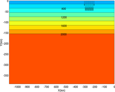
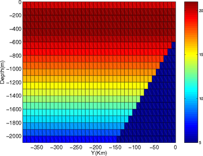
    (left: X-Y horizontal section and velocity vector of the northern inflow), right: Y-Z vertical section (eastern inflow magnitude is scaled in color)

    Main